Phone/Whatsapp: +44 (0)7749 000 889
sam@thejollygeo.com
The Jolly Geo Interrail Journey, 2023 The Jolly Geo Interrail Journey, 2023 The Jolly Geo Interrail Journey, 2023 The Jolly Geo Interrail Journey, 2023
  • Home
  • The Jolly Geographer
    • Raising the profile of geography
    • Thinking of a career as a Geographer?
    • Publications and mentions
    • Socials
  • Projects
    • GEM: A Smartphone App for Mapping Mangroves
    • Gough Island Restoration Programme
      • Gough Blog
    • Project Hogwatch
    • Interrail 2023
    • A map of me!
  • The Jolly Geo Quiz
    • The Xmas Edition – LIVE!
    • The Halloween Edition – LIVE!
    • The Summer Edition – DONE
    • Corporate Bookings
  • Jolly Geo extras
    • The Jolly Geo meets…
    • Geo podcasts
    • Jolly Geo GPS art
    • Jolly Geo book recommendations
    • Solargraphy
    • Granny Gandhi Chai!
  • About The Jolly Geo
  • Get in Touch

GEM: A Smartphone App for Local-Level Mangrove Mapping

    Home GEM: A Smartphone App for Local-Level Mangrove Mapping

    GEM – the background

    GEM is a mangrove mapping tool freely accessible to non-profit users, built using the powerful cloud computing tool Google Earth Engine (GEE). It is available as both a Desktop tool and an Android App for smartphones and tablets.

    The idea for GEM was conceived in 2017 when a gap was identified for a tool that can accurately map mangroves at the local scale, to meet the needs of local mangrove conservation practitioners. Products such as Global Mangrove Watch (first released in 2018) provide excellent mangrove maps for global, regional and national level analysis, but struggle to accurately capture mangrove extent at the local and hyper-local level. Global products often fail to account for local ecological and environmental nuances, leading to maps that are inaccurate or misleading.

    GEM not only allows map-makers to account for their local nuances (for example by providing local ground-truthed data), it also utilises state of the art mapping methods such as accounting for tide state. After all, mangroves are a coastal ecosystem, meaning they appear (and are!) vastly different depending on whether the tide is in or out.  Mapping using imagery captured at high-tide runs the risk of missing mangroves that are inundated by water, and mapping at random, and therefore variable tide levels across time adds confusion to the mapping process. GEM accounts for all of this by using imagery acquired at consistent tide levels.

    Supported and funded by British marine conservation NGO Blue Ventures, the first GEM tool (v1) was released and published in 2020 in the Remote Sensing Journal, where it received an Editor’s Choice Award.
    GEM v2 Desktop Tool

    GEM v2 was released in 2024, bringing significant improvements to map accuracy, notably by utilising the now extensive archive of higher spatial resolution Sentinel-2 imagery, with its 10 m pixels as opposed to the 30 m pixels of Landsat imagery used by GEM v1.  v2 also added land-cover conversion analysis, giving a breakdown of conversion between the different mapped land-cover classes, giving clues as to the drivers of change.

    Access GEM v2 on GitHub.

    GEM App for Android

    GEM App for Android smartphones and tablets was launched in 2024.  It brings sophisticated mangrove mapping to those who really need, in an accessible and simple App format.

    Download GEM App on the Google Play Store.

    A roadmap for GEM v3

    The concept of local environmental or ecological mapping can be applied to more than just mangroves.  Up-to-date mapping of other land cover types is often lacking at the local level, undermining the conservation, restoration, and management of valuable natural resources.  Natural disasters such as tropical storms, floods, earthquakes can render existing maps meaningless, undermining aid delivery and and recovery efforts.

    Repurposing GEM to accurately map these additional land cover types, across user-selected timesteps (e.g. pre- and post-disaster), using the very best freely available satellite imagery, could significantly improve management and response efforts, leading to better, more targetted use of finite resources.

    The opportunities to expand GEM’s focus are vast, notable ones include:

    • Other coastal ecosystems such as seagrass and coral reefs
    • Terrestrial ecosystems such as types of terrestrial forest
    • Wildfire burn scars
    • Pre- vs post-island eradication

    The GEM team is keen to discuss new applications of GEM with customers that have specific requirements, that fit within the vision above.  Have you got an idea of how GEM can be applied?  Please get in touch, email us at sam@thejollygeo.com and let’s see what we can achieve together.

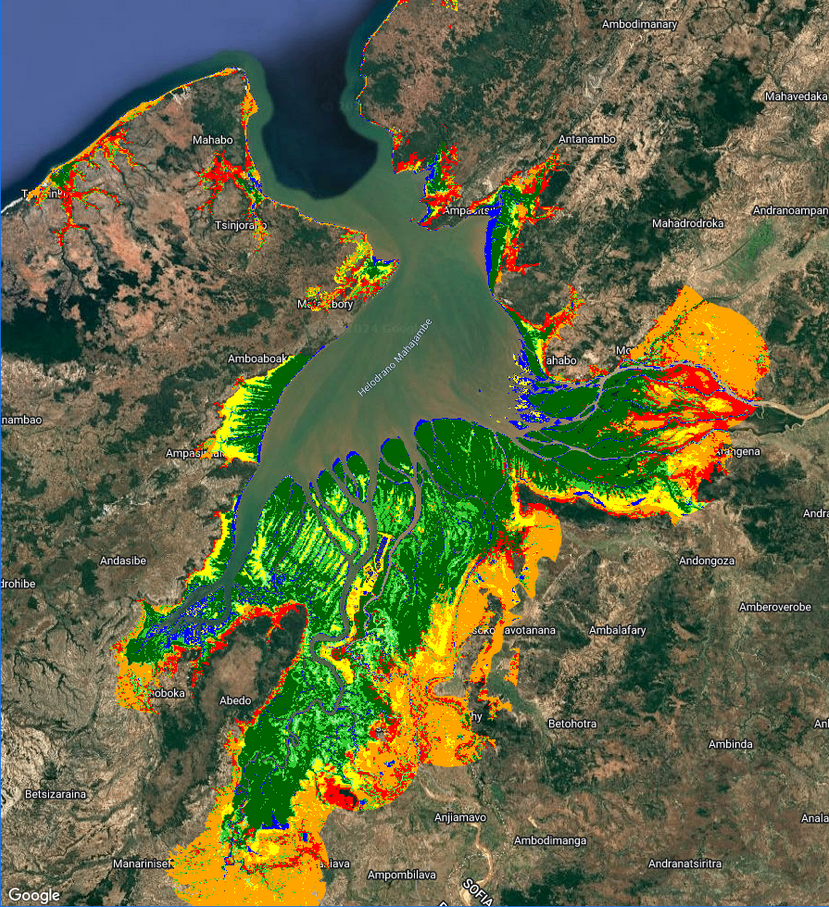
    The mangroves of Mahajamba Bay, Madagascar, as mapped by GEM Desktop v2

    The Jolly Geographer Ltd | All Rights Reserved
    • Home
    • The Jolly Geographer
      • Raising the profile of geography
      • Thinking of a career as a Geographer?
      • Publications and mentions
      • Socials
    • Projects
      • GEM: A Smartphone App for Mapping Mangroves
      • Gough Island Restoration Programme
        • Gough Blog
      • Project Hogwatch
      • Interrail 2023
      • A map of me!
    • The Jolly Geo Quiz
      • The Xmas Edition – LIVE!
      • The Halloween Edition – LIVE!
      • The Summer Edition – DONE
      • Corporate Bookings
    • Jolly Geo extras
      • The Jolly Geo meets…
      • Geo podcasts
      • Jolly Geo GPS art
      • Jolly Geo book recommendations
      • Solargraphy
      • Granny Gandhi Chai!
    • About The Jolly Geo
    • Get in Touch
    The Jolly Geo Interrail Journey, 2023